Extreme Earth: Tornadoes
In equal parts savage and beautiful- the power of nature can be destructive and awe-inspiring. Throughout a series of articles exploring this raw power we discover some of the science behind our Extreme Earth…
In equal parts savage and beautiful- the power of nature can be destructive and awe-inspiring. Throughout a series of articles exploring this raw power we discover some of the science behind our Extreme Earth…
TORNADOES leave a path of devastation and destruction after they’ve assaulted the landscape – how and why they occur is not fully understood, but an international study aims to find out.
Tornadoes are one of the most dangerous and destructive natural phenomena – these violently rotating columns of air can reach speeds of 200 miles per hour leaving a trail of devastation behind them. How and why they occur is still not fully understood as technology – and home video – has only recently evolved to enable meteorologists to study their aggressive lifecycle.

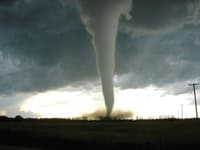
Category F5 tornado viewed from the southeast as it approached Elie, Manitoba on Friday, June 22nd, 2007
The majority of tornadoes occur in Tornado Alley in the United States – an area between the Rocky and Appalachian Mountains covering Texas, Kansas and Oklahoma, although they can occur anywhere. On average, America has 1,200 tornadoes a year, compared with 33 in the UK, although these are not as violent or damaging as their American counterparts. The unique geography of North America allows frequent collisions of warm and cold air - perfect for tornadogenesis.
In May 2010, a group of international meteorologists will gather at the AmericanGreat Plains for the second phase of VORTEX2 (Verification of the Origins of Rotation in Tornadoes Experiment 2) to study how tornadoes form and the pattern of damage they cause. The study area spans over 900 miles from west Texas to southwest Minnesota.
The same meteorologists gathered in the same place a year earlier to observe tornadogenesis – the life cycle of a tornado – during ‘tornado season’. During the month-long expedition, they observed and recorded a single tornado, but this has given them enough data to keep them busy for three to four years.
“It was a dull year,” said Joshua Wurman, from the Centre for Severe Weather Research and inventor of the mobile radar unit – Doppler on Wheels. “We observed one tornado, which was great for science. We watched it for about 15 to 20 minutes before it formed, and then for about 30 minutes until it disappeared.” Wurman said they are still in the early stages of analysing the data.
“It was an ordinary tornado so it’s great for learning,” he continued, “thetemperature and rainfall was normal, the radar showed normal patterns so we’re very hopeful we will gain a lot of information.”
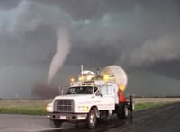
Joshua Wurman's Doppler-on-Wheels
The second phase of this study will be very similar, except they hope be see a few more tornadoes. Wurman hopes to study between five and eight storms that lead to tornadoes, and a further 10 to 20 which do not. He said: “Only 25% of storms make tornadoes – we want to compare data to find out why some storms make tornadoes and why others that could, don’t.”
Meteorologists know tornadoes form from supercell thunderstorms – a storm with a persistent rotating updraft or current of air. Scientists believe the updraft is key to the development of a tornado and is formed when winds at two different levels above the ground blow at different speeds and in different directions. Rising air within the updraft tilts the rotating air from horizontal to vertical1.
Air then quickly descends as a rear flank downdraft (RFD), followed by a funnel which continues to descend while winds build up near the surface, picking up dust and other debris. A funnel cloud is caused by a low pressure creating high wind speeds and rapid rotation causes water vapour in the air to become visible. The funnel is usually a few hundred metres across with a small cloud of debris near the ground.
Warm, moist air keeps the tornado alive until it reaches the mature stage –which can last for a few minutes, or several hours – and it’s during this time most damage occurs. The RFD – now an area of cool surface winds – wraps itself around the tornado, cutting off the warm air feeding the tornado. As it chokes the air supply, the vortex weakens and becomes thin and rope-like. This dissipating stage lasts for a few minutes, after which the tornado dies out2.
Tornadoes occur mostly in the spring and summer when the air is warm and moist, and usually in the late afternoon – between 3pm and 7pm – although destructive tornadoes can occur at any time. They are often accompanied by a dark, greenish sky, wall cloud and large hail, plus thunderous noises. Their colour varies depending on the environment in which they form – a tornado will generally take on the colour of the debris it picks up, while those with little or no debris will appear white or gray.
Evidence from Doppler on Wheels (a mobile radar device) and eyewitnessaccounts suggest that the centre of a tornado is calm, with low pressure and light winds. They track across the ground for roughly one to three miles and have a diameter of between 20 to 100m. Wind speeds can reach up to 200mph, although between 72 and 113mph is typical3. Any circulating surface winds over 40mph are considered tornadoes.
Before the 1950s, the only way to detect a tornado was by someone seeing it on the ground, by which time it was too late for local weather offices to issue a warning. However, advances in technology mean weather radars now provide advanced warnings of severe weather.
Doppler weather stations measure the velocity and radial direction of winds in a storm. They use the Doppler Effect – the change in frequency of a wave for an observer moving relative to the source of the wave – to determine the relative velocity of objects. They can spot rotation in storms from more than a hundred miles away.
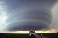
A barrel updraft Credit Reven Wurman
The Doppler on Wheels (DOW) – a mobile Doppler device – was invented by Wurnam. Essentially it is a flatbed truck equipped with hydraulic feet to increase stability, a large radar dish that swivels when in operating mode, and an eight-foot antenna that sends out three-centimetre microwaves. When reflected back by rain, hail, airborne debris, or even insects, the waves create an image of storm activity and indicate wind velocity.
“It was after I completed my PhD, and I was working in radar technology,” Wurman said, “I saw what was currently being applied, and saw where we could be more adventurous, and came up with the Doppler on Wheels. It worked very well – people thought it couldn’t be done but it can and it revolutionised how we could view tornadoes.”
Meteorologists participating in VOTREX2 will use enhanced mobile radars – including the DOW – and other weather-sensing tools to gather detail in the crucial zone where tornadoes develop. They can track wind and precipitation in and near tornadoes in fine detail – instruments have a resolution as fine as 300 feet, and time steps of 15 seconds. They place their equipment about an hour ahead of a potentially tornadic storm and wait until it arrives to record the storm’s progress.
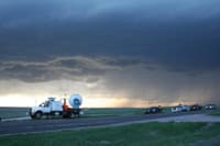
A Doppler on Wheels unit observing a tornado in Kansas Credit Herb Stein, CSWR
Wurman says that once completed the next step will be to analyse the data – which has already reached the Terabyte stage. He says most of the work takes place in the lab, integrating data from radars, weather balloons and tornado pods in order to get a better picture of tornadogenesis.
Many of the groups receive private funding, and the $11.9 million project itself is funded by the National Science Foundation and the National Oceanic and Atmospheric Administration.
It is hoped the experiments will improve the tornado warning system currently in place. Tornado warnings are currently issued around 13 minutes before the expected hit, but it’s hoped this can be increased to at least half an hour. The second phase of VORTEX2 hopes to improve knowledge significantly to reduce the number of false tornado warnings issued – which occurs around 75% of the time. Whatever the outcome of the experiments, anything which can be learned will help to reduce the devastation and destruction felt by so many each year.
Measuring tornadoes
Dr Theodore Fujita, a severe weather researcher at University of Chicago, developed the Fujita scale for rating tornadoes based on their intensity in 1971. It was replaced by the Enhanced Fujita Scale –which classifies tornadoes by the amount of damage caused – in 2007.
| EF rating | Speed (mph) | Damage |
| EF0 | 65-85 | Causes damage to trees, but not substantial structures |
| EF1 | 86-110 | Moderate damage, stripping roofs and breaking doors and windows |
| EF2 | 111-135 | Considerable damage, tearing roofs of buildings and uprooting trees |
| EF3 | 136-165 | Can destroy entire storeys of houses and cause considerable damage to large buildings |
| EF4 | 166-200 | Devastating damage, levelling houses and throwing cars |
| EF5 | 200+ | Can rip buildings from their foundations and deform skyscrapers |
80% of tornadoes are EF0 and EF1 (T1-3) and only 1% are classed as violent – EF4 and T8 or stronger.
TORRO – the Tornado and storm Research Organisation based in the UK – measures tornadoes on the T-scale, which ranges from T0 for a weak tornado and T11 for the most powerful. It is based on the Beaufort scale, which measures wind speed. It is half the Beaufort scale minus 4, so T0 is equivalent to 8 on the Beaufort scale, T11 is equivalent to 30.


